Call Toll Free +1 855-856-TIPS
University of Zurich – AI Powered Drones have shown tremendous promise in the AEC industry as well as their sister and brother, robotics & autonomy. We dive into AI Drones and a report published on October 7, 2021 from the Robotics and Perception Group at the University of Zurich which further shows the potential, including, safety and preservation of workers.
The team, Prof. Dr. Davide Scaramuzza, Antonio Loquercio and Elia Kaufmann, released the research which is summarized after the introduction brief.
AI POWERED DRONES
Integrating GIS and other geospatial tech with AI High Speed Drones and mapping enables powerful new ways for machines to perceive and understand the world.
Advanced capabilities for collecting, analyzing, and forecasting geographic and location-based data have a wide range of applications in agriculture, energy, construction, and even emergency response. Geospatial AI is delivering robust and timely insights across industries by automating both enhanced data exploration and powerful visualization.
Today’s world expects goods and services to be delivered faster, safer, and more reliably. However, logistics and supply chain management must be agile in order to compete beyond retail — from building concept to building operation and everything in between.
AI Drone Benefits In AEC Industry Use Cases
Land Surveying That Is Safe And Affordable
Surveyors can map land mass more quickly and affordably by utilizing a variety of sensor receptors. Image optimization software organizes, analyzes, and selects the best images for planning and resource allocation, while drones provide remote access to potentially dangerous or polluted areas.
Construction Planning That Is More Effective
Drone imagery streamlines construction site workflows by providing decision-makers with spatial data to monitor areas critical to project planning and reporting. Real-time field updates are provided by media and data output, which improves workflow and increases production.
Infrastructure Asset Management Made Simple
Drone software that incorporates machine learning and advanced computer vision algorithms provides faster, more accurate insights into infrastructure assets. For instance, in the aftermath of a natural disaster, drones can quickly and efficiently assess structural damage to commercial buildings and properties.
Reliable Disaster Relief
When disaster strikes, drones and advanced mapping technologies save lives. Drones have quickly become a resource that first responders rely on due to their near real-time situational awareness of people, homes, businesses, and infrastructures during disasters.
Lunch
Whether your eating lunch or an iron worker 44 floors up we all need pizza. And yes, drones can do that too.
University of Zurich
Researchers at the University of Zurich have developed a novel method for autonomously flying quadrotors at high speeds through unknown, complex environments using only on-board sensing and computation. The novel approach may be beneficial in emergency situations, on construction sites, and for security purposes.
When it comes to exploring complex and unknown environments, they are quick, agile, and small, with the ability to carry sensors and payloads almost anywhere. Currently, autonomous drones struggle to navigate an unknown environment without a map, but that appears to be changing according to their report.
“To master autonomous agile flight, you must understand the environment in a split second in order to guide the drone along collision-free paths,” says Davide Scaramuzza, head of the University of Zurich’s Robotics and Perception Group.
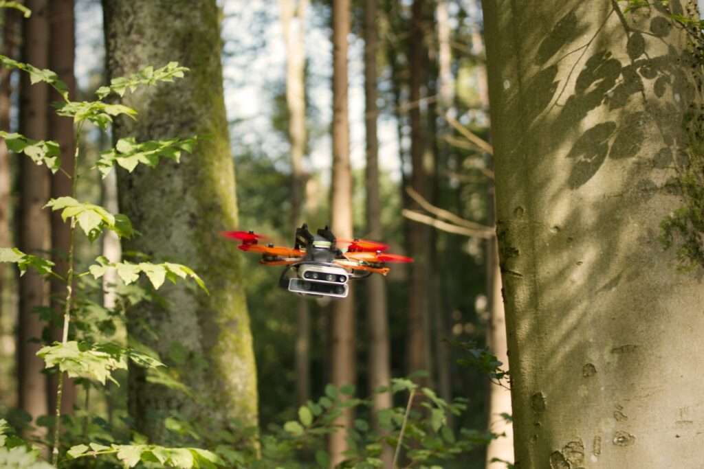
Scaramuzza and his colleagues have trained an autonomous quadrotor to fly through previously unexplored environments such as forests, buildings, ruins, and trains at speeds of up to 40 kilometers per hour and without colliding with trees, walls, or other obstacles, using only the quadrotor’s on-board cameras and computation.
The drone’s neural network was trained to fly by watching a “simulated expert” fly a computer-generated drone through a simulated environment filled with complex obstacles.
Although this “simulated expert” could not be used outside of simulation, its data was used to train the neural network on how to predict the optimal trajectory using only sensor data. This is a significant advantage over existing systems, which first create a map of the environment using sensor data and then plan trajectories within the map – two steps that take time and make flying at high speeds impossible.
There is no requirement for an exact replica of the real world.
Following simulation training, the system was evaluated in the real world, where it demonstrated the ability to fly in a variety of environments without colliding at speeds of up to 40 kilometers per hour. “Whereas humans require years of training, AI can achieve comparable navigation abilities much more quickly, almost overnight,” says Antonio Loquercio, a PhD student and co-author of the paper. “An interesting point to note is that these simulators do not have to be exact replicas of the real world. Even simplistic simulators are sufficient when used properly,” adds Elia Kaufmann, another PhD student and co-author.
Quadrotors are not the only application.
The researchers explain that the same approach could be beneficial for optimizing the performance of autonomous vehicles, or even for developing a new method of training AI systems for operations in domains where data collection is difficult or impossible, such as on other planets.
According to the researchers, the next steps will be to improve the drone’s performance based on user feedback and to develop faster sensors that can provide more information about the environment in a shorter amount of time – allowing drones to fly safely at speeds exceeding 40 kilometers per hour.
University of Zurich
Prof. Dr. Davide Scaramuzza
Robotics and Perception Group
Department of Informatics
University of Zurich
Phone: +41 44 635 24 09
Antonio Loquercio
Robotics and Perception Group
Department of Informatics
University of Zurich
Phone: +41 44 635 43 73
Elia Kaufmann
Robotics and Perception Group
Department of Informatics
University of Zurich
Phone: +41 44 635 43 73


